Editor’s note: John Morrone, one of our WildSnow readers, works at BLM. With access to the original location documentation for all Colorado mining claims, and associated expertise, he did this patent review for Gold Hill Development claims in Bear Creek (Telluride, Colorado). Bear in mind that the original federal patent is the controlling document for boundary definitions, but when overlapping claims exist it can take a bit of work to decipher things. Morrone did the work and concludes there is no gap between claims that could be used for public access. But his other info is interesting as well, so I’ll just publish it for the record. Following lightly edited for clarity.
Mining claim ownership in Upper Bear Creek Canyon, Modena and Gertrude claims area, by John Morrone.
Per federal mining law, ownership and rights of mining claims are dependent on earliest date claim having superior rights over later mining claims. As such, where mining claims overlap, the younger claims rights are secondary (“excepted”) to the oldest claims. The area of the Modena and Gertrude mining claims include several overlapping and conflicting claims.
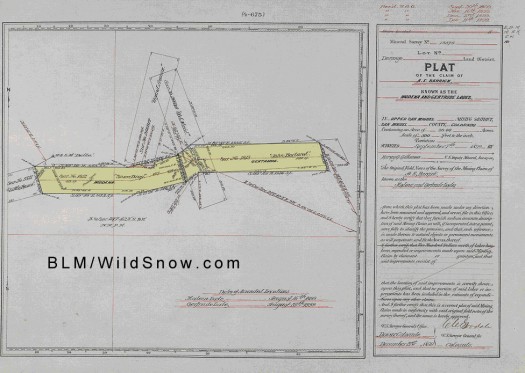
The original federal patent title certificate No. 1802 to the Modena and Gertrude mining claims was issued on January 24, 1906, with signature of T. Roosevelt, title number 43335, subject to mineral survey No. MS13375 (maps 1 & 2).
In this patent document, the area and rights of the Modena and Gertrude mining claims are described, including the statement:
“expressly excepting and excluding from these presents all that portion of the ground herein before described embraced in said OLD MAID and GRAND AVENUE LODE claims, survey no. 2660A, and that portion of said survey No. 1812 in conflict with said GRAND AVENUE LODE claim survey No 2660A, and those portions of said survey Nos. 1812 and 1813 in conflict with said OLD MAID LODE claim survey No. 2660A, and also all veins, lodes and ledges throughout their entire depth, the tops or apexes of which lie inside of such excluded ground, the granted premises in said lot No. 13375 containing twenty acres and four hundredths of an acre of land, more or less.”
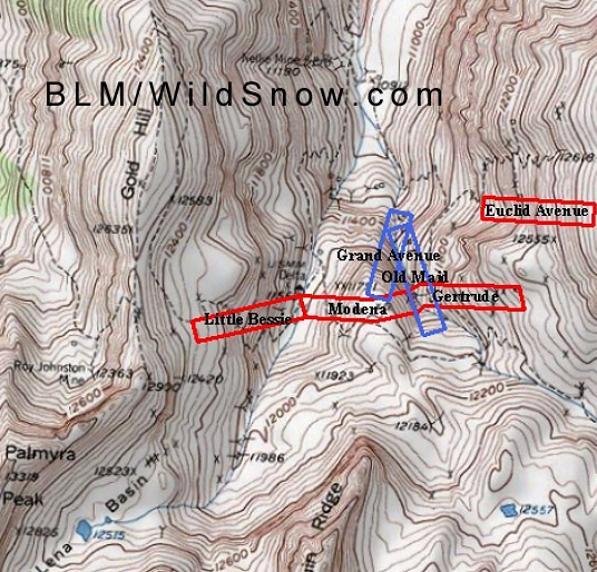
The above statement means that the Modena and Gertrude claims are not typical simple rectangular mining claims (or some slight variation with two extra corners), but exclude any conflicts where overlapped by the pre-existing Old Maid and Grand avenue claims (see map 1). From this it appears that Mr. Chapman’s and Gold Hill Development claims may have breaks in their cross-valley transect, allowing for non-trespass travel.
But it gets more complex:
The title for the Old Maid and Grand Avenue claims notes that they are excepted by two other pre-existing claims: the John Borland claim, and the Snowdrop claim. These claims happened to be in very similar position to the Modena and Gertrude claims (see map 2). The title to the Old Maid and Grand Avenue claims was issued in 1891, and excluded any conflict areas with these 2 older claims. When viewed in the detailed survey map, much of the conflict excepted from the Old Maid and Grand Avenue by the earlier claims (JB and Snowdrop) is so similar to the Modena and Gertrude, that most of the Old Maid and Grand Avenue claims do not have significant ownership infringing on the Modena and Gertrude. This leaves only 0.31 aces of conflict (very small triangles near the north and south edges of the claims) removed from the Chapman claims. Hence the upper forks of Bear Creek indeed have a private land transect cutting them controlled by Mr. Chapman. In other words, there is no gap that could be used by the public to avoid private land.
Map 1. Topo Map Showing Location of Subject Claims in Bear Creek Canyon
Claim Locations based on BLM cadastral survey connecting sheet data.

BLM topo map showing Bear Basin, Gold Hill Development parcels and others.

Mineral Survey Map MS 13375, upper Bear Creek Canyon. Original mining claim plat showing Gold Hill Development parcels. Click image to enlarge.
Beyond our regular guest bloggers who have their own profiles, some of our one-timers end up being categorized under this generic profile. Once they do a few posts, we build a category. In any case, we sure appreciate ALL the WildSnow guest bloggers!
