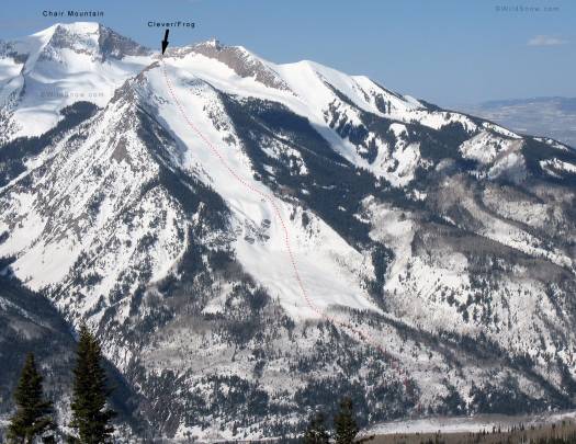
When you’re driving up HWY 133, south from Carbondale, Colorado this big mountain ski line pulls your attention like finding a $100 bill on the street. I can’t believe it’s taken me several decades to pick up the money.
I teamed up with Lynn, Chad and B.J. for the 4,100 vertical foot climb and descent. Though whipped from yesterday’s fun with “two lap Bob,” I still managed to keep up with B.J. and make the climb in 2:45 — perhaps the past five months of backcountry skiing are starting to improve my cardio? Let’s hope so. In any case, rest day tomorrow.
 |
| Chad near the summit, 3,500 vert of perfect corn snow waits below. |
| View of Cleaver from east, high peak is Chair Mountain. Click image to enlarge. Locals also call this the “Frog.” |
 |
| Lynn and Chad just below the top. |
 |
| What the Cleaver/Frog looks like from HWY 133. Pick up the C-note some time. |
 |
| Easy to find on the USGS map. Summit GPS UTM WGS84: Zone 13, 303375 E — 4326797 N Trailhead GPS UTM WGS84: Zone 13; 305825 E — 4328625 N Skiing is car-to-car with no flat approach walk or dirt hiking. The lower part does melt off early, so timing is everything — late April during a corn cycle being the ticket. Trailhead marked on Google Map below. |
Now, how about some trivia? The reason why this run is so stupendous is that a gigantic avalanche on January 12, 2005, mowed down a large expanse of aspen forest at the bottom of the route, thus creating much more aesthetic ski terrain. If you zoom in on the Google map as far as possible, you can see the knocked over aspens looking like combed hair. The slide was so huge it got honorable mention on the Colorado Avy Info website. God’s lawnmower, indeed.
WildSnow.com publisher emeritus and founder Lou (Louis Dawson) has a 50+ years career in climbing, backcountry skiing and ski mountaineering. He was the first person in history to ski down all 54 Colorado 14,000-foot peaks, has authored numerous books about about backcountry skiing, and has skied from the summit of Denali in Alaska, North America’s highest mountain.

