I’m needing a foundational GPS and mapping system that provides:
1. Integration with web based trip planning tools “desktop companion” that cloud stores all completed trips, either public or private.
2. A variety of map layers, including easily zoomed USGS type raster topos and high quality European topo maps.
3. Easily published routes via iframe embeds for blogging etc.
4. Quick setup of smartphone during connectivity for use in areas with no data connection.
5. Smartphone app that blends with cloud using previously created routes and providing full GPS functions. See review of Trimble Navigator app.

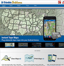
Trimble Outdoors website home screen could be cleaner and more compact, but it does the job. When browsed on smartphone a mobile version with lower bandwidth would be appreciated, but you basically get the same thing only too small to read unless you swipe to enlarge.
Trimble Outdoors is one option. First, what’s free and what costs? The Trimble free-side lets you view routes on their maps — some routes are free, some you pay to download. Costs are confusing but basically work like this: month subscription $3.00; year is $29.99. Other parts are available by the piece, but confuse the cost issue and are thus not worth mentioning.
Quick cost summary: My concern with this sort of thing is the old axiom of the digital world: “The more you pay, the more complicated and poorly designed the software will be.” My take is Trimble dances on the edge of that sword, but comes out on the better side. For significantly more money than a basic one-time-nine-dollars phone app, you get desktop companion, cloud storage of your trips, trip publication options, but only 7 map layers, several of which are seemingly redundant Bing maps that just clutter up the list. (The Trimble smartphone app is also “free” initially and has similarly limited functionality. It goes full-function once you buy a membership.)
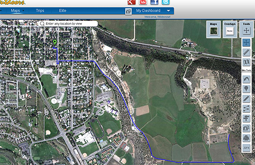
Below is an example of a trip I created with Trimble’s desktop companion. I found the drawing tools to be simplified but surprisingly robust. One test of mapping software is how smoothly a route will draw with a mouse. Trimble does it in small segments that eliminate nearly all mouse “scatter” no matter how much espresso you’ve poured. Another test is how the drawing tool behaves when you go off the edge of your screen view. If you go off the Trimble screen edge with the continuous drawing tool the screen scrolls and you end up with a line you didn’t intend. But the work-around is easy: just stop drawing for a moment, get to the screen edge, click somewhere off your route, use the hand tool to move your map view, then commence drawing again.
Below, I had published/shared/embedded a trip/route I created on the fly. Worked well for a while, but ceased to function in spring of 2014 so I deleted. When it worked, here were some takes: I’m not impressed with how viewing a photo fires the website and over to Trimble’s page like your mouse is a canon trigger. A lightbox style image enlargement would be much more professional and more fair to hard working publishers providing Trimble with what’s essentially free content. This discourages me from wanting to drop photos on a trip that I’ll embed on my own publication. (Professional content creators should note that once you add media content to Trimble, they’re using your creative as their own content for which they charge money.) Hopefully, you can see an example of this route embedded over at hutski.com. But no guarantees it’ll continue to function there, at that’s up to Trimble — as of spring 2014 it indeed stopped working, through no fault of my own. Frustrating.

Trimble in route drawing mode, using Google sat view. Quite easy to create a 'trip.'
Details, based on Trimble’s list of regular Features.
“View 10 different map types: streets, aerial, topo and terrain. Get exclusive access to 68,000 detailed MyTopo maps in US and Canada.”
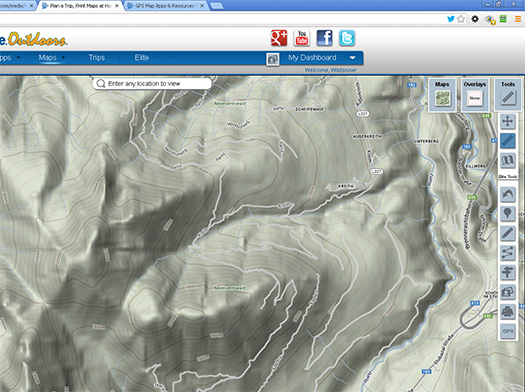
— Trimble includes three totally redundant Bing map views, and only one USGS based topo map (Trimble’s My Topo). “68,000” is an old-school way of describing what most people are using as seamless digital maps, as in, who cares? And how about Europe? Only European topo layer Trimble provides is Open Map, which slow to load and not as good as the beautiful and free Alps map available at http://www.wanderreitkarte.de/garmin_de.php. When I tried to view other map layer options with a view of the Alps, the map screen simply did nothing — confusing.
While the Trimble smartphone app does provide for caching maps so they’ll work without a data connection (easy to access and quite intuitive), they also sell cards pre-loaded with maps sets for different states. The card for Colorado costs $69.99, which seems expensive but does probably include licensing fees and production overhead. Having all the maps for your region of operation pre-installed in your smartphone most certainly is a way of avoiding the annoyance of pre-caching — perhaps worth the money.

Only topo map Trimble seems to have for Europe is Google terrain view. This is totally inadequate in comparison to available free map products.
“Drop waypoints on the map.”
— Works well.
“Search for trails, peaks, lakes, rivers and more.”
— Trimble search is slow when finding routes (and was offline one time I tested). Too many random routes junk things up, limited filtering options don’t include backcountry skiing, climbing, x-c skiing. Clutter includes things like a mile long walk on city streets, probably good if you’re in that city, but better focus could be useful.
“Use the Ruler to measure distance between two points.”
— Useless. Only measures straight line. Once you complete creating a trip, you get the full data pile including distance, elevation profile, etc.
“Draw tracks in 3 different modes (freehand, point-to-point, follow streets)”
— Tools are simple and work fine once you familiarize.
Add photos, videos, and YouTube links
— Works fine, though image zoom is a bit primative (a lightbox effect would be nice).
Import GPS files (.GPX) or upload files from your Garmin device
— Will utilize any properly created .gpx file.
“Print maps on your home printer. Order custom printed topos and aerial from MyTopo.”
— Set yourself up with waterproof paper system, or just order nice topo maps from Trimble.
“See GPS grids (lat/long, UTM)”
— Yawn.
“Send trips to Google Earth (KML, KMZ)”
— Standard functionality for any good mapping and GPS system.
“Access trips from the Trimble Outdoors Cloud.”
— This is a part that’s important to me. Publishing from cloud as well.
“Send trips to our smartphone app and tablet app. Privately share trips with friends.”
— Basically, you can do what you want with the trips you create. Important to have control of publication.
The Map List
Does Trimble provide anything out of the ordinary and elsewhere available for free? Really, no, but like most of today’s GPS/map applications they take what you could otherwise view for free and integrate with their applications — to greater or lesser effect. (Bear in mind that an above-the-radar commercial mapping/GPS company such as Trimble is paying to license maps such as Google, which is one reason they may cost more than companies who are flying under the radar and possibly providing maps without paying for them.)
— Google street maps. Free elsewhere
— Hybrid Google view (sat and streets). Free elsewhere
— Google terrain view. Free elsewhere.
— My Topo. Trimble company that sells shaded USGS raster graphic topo maps available in other forms in many other places.
— Open Maps (street and terrain views). Free community-based mapping, slow to load and a solution without a problem.
— Bing Maps (street and sat views, no topo view). Redundant maps that just clutter up the user interface.
Conclusion:
I find both Trimble’s desktop companion as well as their smartphone app to be useful, and possibly my go-to for publishing routes on my websites. If all you need is a map displayed on your smartphone, with associated GPS date, you can find options that cost less but do not have the easy desktop functionality and publishing features. Better European maps would be appreciated, as would a lightbox effect when viewing photos attached to trips. Trimble cost levels are confusing, with memberships called both “Elite” (the annual subscription for everything) and “Pro” (paid version of the stand-alone smartphone app). Note that if you create a trip, you continue to “own” it and even if your membership lapses, and it will probably remain published and embedded if you’ve done so on a blog or elsewhere. (On the other hand, Trimble does say in their terms of service, they reserve the right to delete trips.) I like Trimble’s cloud based storage, easy embed publishing option, and their simple route drawing tools. Their hardware solutions such as maps on a card complete the smartphone/desktop/hardware triad, but appear pricey. In all, a system I’ll continue to use, may expand with and recommend exploring for anyone needing full GPS/desktop integration (free 14 day demo is available).
–
WildSnow.com publisher emeritus and founder Lou (Louis Dawson) has a 50+ years career in climbing, backcountry skiing and ski mountaineering. He was the first person in history to ski down all 54 Colorado 14,000-foot peaks, has authored numerous books about about backcountry skiing, and has skied from the summit of Denali in Alaska, North America’s highest mountain.
