GPS Reviews
It’s a mystery why it happened, but in a limited way I’ve become somewhat of a GPS geek. Nothing like the guys who live and breath the things, but I’ve dug into the issues of compasses, button controls vs touch screens, map quality and more. So with my WildSnow biases in full force I visited GPS purveyors at the recent Outdoor Retailers trade show.

Garmin 62 series GPS are easily our top pick for backcountry skiing.
First, know that we don’t recommend touch-screen GPS units for winter backcountry navigation. So I don’t bother even thinking about the things when it comes to opinionating. While some of the touch units have a “glove friendly” screen, that’s still not mitten or “big glove” friendly, nor is it going to behave kindly to having freezing rain and snow wiped off. Also, we’re not big fans of all the “wrist” and “watch” GPS units flooding the market. Sure, they look cool, but most (if not all) do not lend themselves to displaying a topographic map for blind navigation; they’re more for tracking your trip or following a pre-existing track.
Delorme is always interesting to check out. Their Earthmate PN-60 has the required button controls, and trumpets should blast from the heavens proclaiming the available buttons-locked mode. While the unit does have a 3 axis GPS compass that works well while you’re moving, it has no magnetic compass. Thus, if you’re standing in a whiteout with a 300 foot cliff just out of sight behind you, you might end getting a good scare while trying to get yourself headed in the correct direction. That’s a deal breaker for me, but add to that what appears to be the geeky hassle of using 3rd party maps (Europe?) with the Earthmate, as well as the necessity of a proprietary (whoops I forgot it) data transfer cable instead of standard USB, and we definitely can not recommend the Delorme PN-60. (Note, PN-60w version is around $50 more with Delorme’s “Topo North America” map pack. While we do see the potential DeLorme has in their mapping software and data, every time we look at it we’re underwhelmed.)
Next up, Magellan provides several button controlled models in their eXplorist series (is anyone else tired of product names starting with a small case letter?). No button lock with these guys, but they do have an interesting “suspend” mode that turns off everything but tracking and results in greatly extended battery life. The suspension takes only a few button clicks, so you could conceivably do it over and over again while pocketing the Magellan, but it is still not the basic control lock we’re looking for; that which still allows viewing your progress on the map but “safes” the buttons. Again, deal breaker is no magnetic compass, and the fuzzy bitmapped USGS topo maps (sourced from National Geographic Topo software) didn’t excite us either, though they did scroll with nearly seamless speed. Again, I couldn’t see any easy way to get European fine detailed topographic maps into the Magellan eXplorist GPS unit, and the guys in the Magellan booth were not much help with a definite answer on that. Commenters, feel free to set us straight.
Garmin has been terminally cute for a while with their eTrex series handhelds. We’ve owned a few of these, and while the eTrex form factor is terrific (other than the tiny screen) the joy stick control of the fully featured eTrex models is a royal pain in that it gets knocked around so easily while pocketing. Whatever, no big reason to use the eTrex since Garmin also sells their GPSMAP 62 series models.
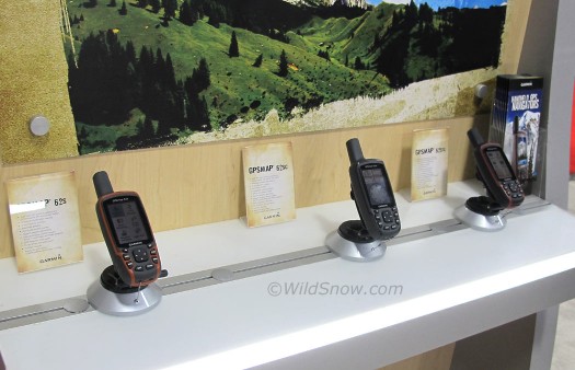
The Garmin GPSMAP 62 magnetic “digital” compass works in seamless combination with the GPS compass, switching back and forth depending on your movement and availability of sat signals. The compass is three axis so it works when the GPSMAP 62 is tilted — as well as when you’re sitting still inside a building doing things like route planning or simply attempting to identify the mountains you’re viewing from the window. I tested the 62 series compass inside the OR Show convention hall. The thing is impressive. Nearly zero lag. Almost like using a magnetic needle compass only it works while tilted. Also, you can configure the display so a compass window displays over your map. That is beautiful, though the compass window does obscure quite a large area of the map underneath. Sadly, no control lock, but the GPSMAP 62 buttons are sufficiently stiff to prevent most accidental presses.
Garmin’s Mapsource computer software isn’t breathtaking, but it gets the job done. Main thing is you can find tens of thousands of free maps on the web that with a simple download will display in Mapsource, and with a few mouse clicks will upload into your GPSMAP 62. That includes Europe. And if all else fails, Garmin themselves sell their albeit expensive but easily available topographic maps for numerous countries.
In summary. The consumer targeted handheld GPS market has vastly improved their products during recent years, but we still find much to be lacking when it comes to hard-core blind off-trail navigation in full conditions. Based on our overview and hands-on use at the OR show, we can not in good faith recommend any GPS models other than the Garmin 60 and 62 series units.
If you’re shopping, here is the lowdown on the Garmin GPSMAP 26 series flavors. Base unit 62 is not recommended, sweet spot seems to be the GPSMAP 62s which has the better compass but doesn’t make you pay for a BS camera and pre-loaded semi-useful maps. You can also go more pricey than the 62s, to a couple of units that have do have preloaded large-scale maps (useless for detailed navigation) and, whoopeee, cameras. Shop for GPSMAP 62s here.
Designers are notorious for not listening to anyone but their own team, or being stone deaf to anyone but themselves. But in case someone out there in GPS design land is listening, below is our short list of what we view are the most desirable features of present and future handhelds. Include most of these, and perhaps we’ll keep buying your rigs instead of just using Google Maps on a smartphone.
– Stiff, big keys that work with gloves and are not easily moved accidentally.
– Camera, who cares.
– Control lock in firmware, such as that of the DeLorme.
– No geek credentials required to download and install free maps.
– Pre-installed fine detail (1:24000) topo maps for all of North America & Western Europe
– Detailed compatible topo maps (e.g, 1:24000) available for many parts of the world.
– Large LCD in comparison to unit size.
– AA batteries, lithium ok.
– Non color, battery saving LCD display mode as a control option.
– Compass that functions indoors and/or when stationary, when unit is flat or tilted.
– Customizable controls and display to streamline workflow.
– Flashlight LED (yeah, I know, but I like having the emergency light source and it’s so easy to include).
– Seamless fast map scrolling, no stuttering
– Suspend mode that turns everything off but tracking.
– Sunlight readable display (don’t really need to list that, but might as well).
– USB interface, no proprietary bull that requires yet-one-more-cable-left-at-home-groan.
– Barometric altimeter, and clarity about this vs GPS derived elevation.
WildSnow.com publisher emeritus and founder Lou (Louis Dawson) has a 50+ years career in climbing, backcountry skiing and ski mountaineering. He was the first person in history to ski down all 54 Colorado 14,000-foot peaks, has authored numerous books about about backcountry skiing, and has skied from the summit of Denali in Alaska, North America’s highest mountain.
