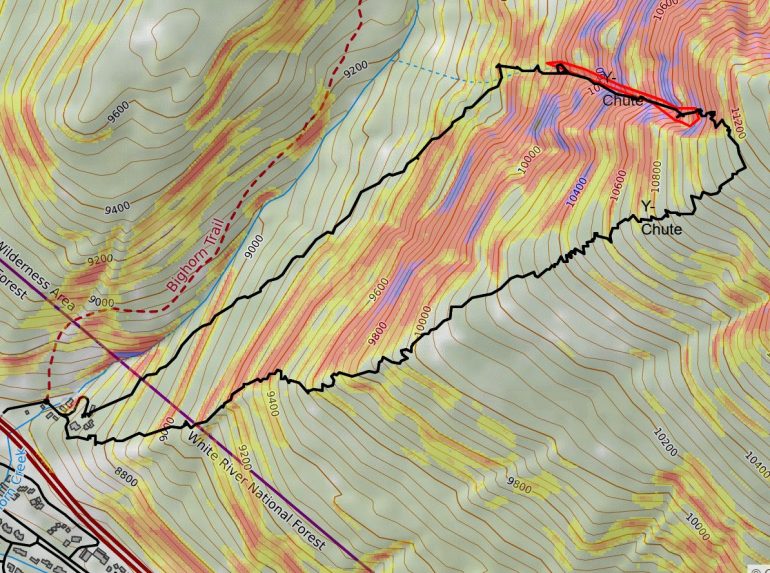
CalTopo allows you to isolate the specific zone you want to ski.
Weighing the offline backcountry navigation options
As backcountry enthusiasts, we’ve all been there: pouring over CalTopo in the dark hours of winter, planning our next grand adventure or searching for that secret powder stash. We play with satellite imagery, track wind plots and check slope angle, all with the goal of moving more efficiently and safely through the mountains. It is truly incredible the amount of information we have at our fingertips from the comfort of our pajamas.
But how does this information translate to use in the field? When we click into our skis and leave the trailhead, how can we best utilize the detailed route plan we built on our computer? Traditionally I have used the Avenza app for this purpose, but in recent times have switched to the recently released CalTopo App. In this article, I will discuss the features, pros, and cons of each.
Advantages of bringing an annotated CalTopo map into the field
It’s no secret that heuristics play a role in our decision making in the field. For this reason, I try my best to make decisions about which terrain to open or close before I even leave my house. CalTopo has proved to be an invaluable tool for this application (see Aiden Goldie’s WildSnow article on how to use CalTopo’s features). When I come up with my trip plan for the day, I use CalTopo to draw polygons around the terrain I am comfortable (or not) traveling through. This way, when I am in the field, I can keep my little dot inside those polygons throughout my tour. This has helped me align my in-field decision making with the less heuristically influenced tour plan I built at home.
Another reason it is especially useful to bring CalTopo into the field is that phone apps give you the ability to track your tour via GPS tracking. Not only does this give you the ability to see where you’ve been in live time in the field, but after your tour you can upload these tracks onto your computer. I upload all of my tours from my local range to a ‘master’ Caltopo map so I can reference them later on. If your desired run has a tricky entrance or exit, you can follow your exact route, time and time again. Furthermore, having this data provides feedback that we can utilize to maximize our margins of safety in the backcountry.
Using CalTopo with Avenza
Avenza focuses on delivering powerful mapping software for both professional and recreational applications. For the backcountry user, the mobile app gives you the capability to track your location offline in live time with GPS capabilities built into your smartphone. For the ski-tourer, Avenza allows you to import maps with QR codes which means you can download your pre-built CalTopo map for offline use in the field. This was a game-changer for me as it gave me the ability to bring CalTopo’s full toolbox with me in the field.
Once you have your desired map built in CalTopo, the next step is to download the map to the mobile app so you can follow your location in real time in the field. The beautiful thing about Avenza is that it allows you to download your CalTopo map exactly as it shows up online — layers, markups, satellite imagery and all. In order to do this, you first need to export the CalTopo map as a pdf. Click the ‘print’ button at the top of the page, selecting a region of the map you want to use, and then export it as a pdf.
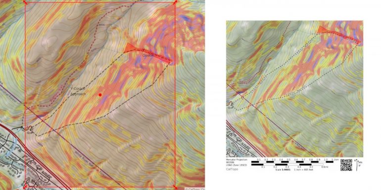
The selected portion of your CalTopo map can then be converted into a PDF.
Once you export your map, CalTopo generates a QR code that you can then use to import to Avenza. When you are in the ‘My Maps’ tab of Avenza click the ‘+’ arrow in the upper right hand corner, click the QR code icon and then you can scan the QR code to upload your map. Once you have the map uploaded, you can track your location in real-time in the field.
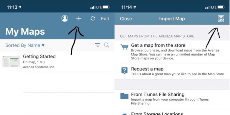
Once in Avenza, it’s easy to upload your pre-made CalTopo map.
For a free mapping app, I have gotten incredible use out of Avenza. Offline tracking of my pre-downloaded CalTopo map has been a game-changer for my ski-touring.
Limitations of Avenza
As much as I have enjoyed using the Avenza app, there are limitations. First and foremost, the free version of the app only allows you to store three maps at a time. While this isn’t a huge deal if you are diligent about uploading your tracks and pin locations as .kmz files, it adds steps every time you need to download a new map or upload your tracks or pins. There have been several times I’ve lost my GPS tracks because I forgot or didn’t have time to upload data to my computer, and so I deleted a map to make way for another. If you upgrade to their ‘Plus’ version for a $29.99 yearly subscription, you can download unlimited maps to the app for all of your touring needs.
The second limitation I have noticed with the Avenza app is that there is a decrease in quality when you download a larger piece of mapped terrain from CalTopo. Because the map is not ‘live’, the topo lines do not re-calibrate as you zoom in on terrain features which can result in a fuzzy picture if you download a larger area. As a result, I typically end up downloading individual maps for each tour so I can map a smaller area and thus enjoy a higher definition. When you consider that Avenza only allows you to store three free maps for free, you can see where this becomes a nuisance.
Enter the CalTopo App
Since the unveiling of Avenza, CalTopo has released their own app that gives you the power of their web platform in the palm of your hand. Just like Avenza, this gives the distinct advantage of being able to utilize detailed CalTopo maps in real-time in the field. You can build annotated maps and routes on your phone, or you can sync the ones you built on your computer. All you need to do is log into your CalTopo account, and you instantly have seamless access to their features.
When you log into the CalTopo app, the interface will feel very familiar. In the upper right hand corner, the map displays the GPS coordinates and elevation just like on the website. Directly above that, the ‘layer’ icon gives you access to the same powerful features as the website. You can choose your base map, overlay wind plots or slope angle shading and even look at real time data from various weather and SNOTEL stations. Additionally, the app also allows you to annotate your map right from your phone. The bottom line is that the CalTopo App gives you virtually all of the same capabilities as the website, in a user friendly and familiar interface.
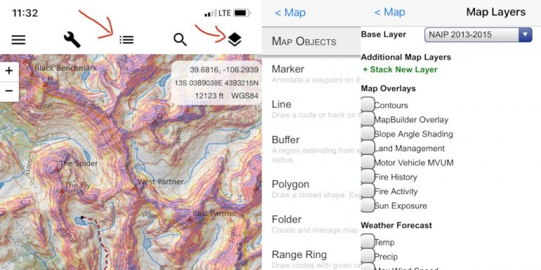
The CalTopo mobile app gives you the same power to change ‘layers’ and build ‘objects’.
CalTopo App vs. Avenza
In theory, you can build the same maps on the CalTopo online platform and then download them for offline use on the Avenza app. So why is CalTopo the superior app? For me, there are three features that set it apart.
Map Definition: when you scroll an area on CalTopo, the app gives you the ability to zoom on different features with much higher clarity. Instead of zooming in to see the pixelated slope angle shading, the CalTopo app will recalibrate topo lines as you focus on a smaller terrain feature.
Offline Features: With the CalTopo App, you can draw polygons, lines and drop way points along your tour. You can also get information about those annotations. One of the most common times I use this feature in the field is when calculating the remaining distance and elevation of a climb. I will draw a line from where I am to where I want to go, and then I can learn about the route’s elevation gain, slope angle and overall distance. These features are in addition to the route tracking, elevation and compass features you can find on the Avenza App. Long story short, the CalTopo app gives you access to incredible information regardless of cell service.
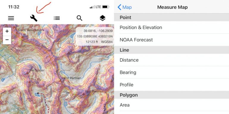
Check your bearing, measure distance, and look at terrain profiles regardless of your cellular connection.
Seamless Integration: When you sign into your CalTopo account, every map, annotation and track you’ve built on the online platform is automatically available on the app. You never need to worry about syncing or downloading. Just make sure your cell phone is fully charged and you’re ready to go.
CalTopo App downsides
In order to access offline tracking, a CalTopo subscription is required. Plans start at $20/year for access to online tracking and go up from there depending on which access you want. I purchased the ‘Pro’ membership for $50/year which gives me access to every map layer both on and offline. Other than the cost I have not experienced any downsides to this software- especially in comparison to Avenza.
Bottom line
If you like to backcountry ski, CalTopo is the superior trip planning tool. If you backcountry ski where there is no cell service, it is incredibly useful to have the ability to track your location in live time on an annotated map. Avenza and CalTopo both achieve this goal but if you are willing to pay for a yearly subscription, there is really only one option. The CalTopo App offers superior map definition, offline features, and online integration. If you are really pinching pennies and don’t tour as frequently in consequential areas, then Avenza can definitely work. My opinion? Pay for a CalTopo subscription and support the incredible resource that we all rely on.