– The Backcountry Ski Site
  • Avalanches
  • Gear Reviews
    • Ski Reviews
    • Boot Reviews
    • Binding Reviews
    • Snowboard Splitboard
    • Book Reviews
    • Avalanche Beacon Reviews
    • Airbag Backpacks
    • Backcountry Electronics
    • Misc Gear Reviews
  • Podcast
  • Tips & Tricks
    • Ski Touring Basics
    • Boot Fitting
    • Fitness & Health
    • Gear Mods
  • Trip Reports
    • Fourteeners
    • Huts – Cabins – Lodges
    • Denali McKinley
    • 8,000 Meter Skiing
  • Stories
    • History
    • Humor
    • Land Use Issues
    • Evergreen Ski Touring
    • Poetry
  • Resources
    • All Posts Listed
    • 100 Recent Comments
    • Backcountry Skiing & Ski Touring Webcams
    • Ski Weights Comparison
    • Archives of WildSnow.com
    • Authors Page
    • Ski Touring Bindings
      • Trab TR2 Index and FAQ
      • Salomon Guardian & Tracker
      • Naxo Backcountry Skiing Bindings – Info Index
      • Silvretta Pure Backcountry Skiing Bindings – Info Index
      • Marker F10-12 Duke Baron
      • G3 Onyx Ski Binding FAQ
      • G3 ION Ski Touring Binding
      • Fritschi Backcountry Skiing Bindings – Info Index
      • Fritschi Diamir Frame Bindings Mount DIY
      • Fritschi Diamir Bindings FAQ
      • Fritschi Tecton FAQ
      • Atomic Salomon Backland MTN
      • Dynafit Tri-Step Binding 2001-2003
      • Naxo randonnee alpine touring AT ski binding FAQ
      • Dynafit Skiing Bindings – Info Index
      • Dynafit Binding Frequently Asked Questions FAQ
      • Dynafit Beast 16 FAQ Review 1
      • Dynafit Beast 16 FAQ Page Two
    • History
      • Ski Touring Binding Museum
      • Trooper Traverse Intro & Index
      • Randonnee Ski Touring “AT” ski gear — What is Hip?
      • Chronology
    • Backcountry Skiing Core Glossary
    • Gear Review Policy & Disclosures

– The Backcountry Ski Site

  • Avalanches
  • Gear Reviews
    • Ski Reviews
    • Boot Reviews
    • Binding Reviews
    • Snowboard Splitboard
    • Book Reviews
    • Avalanche Beacon Reviews
    • Airbag Backpacks
    • Backcountry Electronics
    • Misc Gear Reviews
  • Podcast
  • Tips & Tricks
    • Ski Touring Basics
    • Boot Fitting
    • Fitness & Health
    • Gear Mods
  • Trip Reports
    • Fourteeners
    • Huts – Cabins – Lodges
    • Denali McKinley
    • 8,000 Meter Skiing
  • Stories
    • History
    • Humor
    • Land Use Issues
    • Evergreen Ski Touring
    • Poetry
  • Resources
    • All Posts Listed
    • 100 Recent Comments
    • Backcountry Skiing & Ski Touring Webcams
    • Ski Weights Comparison
    • Archives of WildSnow.com
    • Authors Page
    • Ski Touring Bindings
      • Trab TR2 Index and FAQ
      • Salomon Guardian & Tracker
      • Naxo Backcountry Skiing Bindings – Info Index
      • Silvretta Pure Backcountry Skiing Bindings – Info Index
      • Marker F10-12 Duke Baron
      • G3 Onyx Ski Binding FAQ
      • G3 ION Ski Touring Binding
      • Fritschi Backcountry Skiing Bindings – Info Index
      • Fritschi Diamir Frame Bindings Mount DIY
      • Fritschi Diamir Bindings FAQ
      • Fritschi Tecton FAQ
      • Atomic Salomon Backland MTN
      • Dynafit Tri-Step Binding 2001-2003
      • Naxo randonnee alpine touring AT ski binding FAQ
      • Dynafit Skiing Bindings – Info Index
      • Dynafit Binding Frequently Asked Questions FAQ
      • Dynafit Beast 16 FAQ Review 1
      • Dynafit Beast 16 FAQ Page Two
    • History
      • Ski Touring Binding Museum
      • Trooper Traverse Intro & Index
      • Randonnee Ski Touring “AT” ski gear — What is Hip?
      • Chronology
    • Backcountry Skiing Core Glossary
    • Gear Review Policy & Disclosures
   

Let the (Smart) Games Begin

by Lou Dawson July 17, 2013
written by Lou Dawson July 17, 2013

Update: I added some app evaluation links below, including Trimble and Backcountry Navigator Pro. Galaxy Note phone is working super well. It feels like marriage, when you know you’ve found “the one.” I took the battery out today to test for swapping in the field, easy but would need to be done in a dry environment as doing so exposes the micro SD and SIM cards. An external battery pack might be a better option, but so kludgy with a cord…the games continue.

I may be involved in a web publishing project that focuses on mapping. So I ramped up my GPS experiments. Focus is now on smartphones, which ones work for “real” backcountry GPS use?

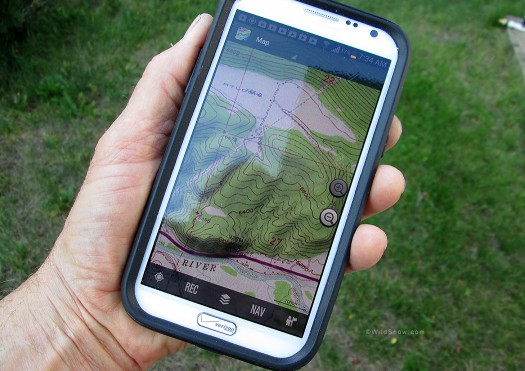
Samsung Galaxy Note 2, in service as GPS mapping device.

Samsung Galaxy Note 2, in service as GPS mapping device.

Issues:
1. Battery Life
2. Screen visibility
3. Use in cold temperatures, possibly with gloves.
4. Works in Europe, with good European maps.
5. Moisture resistance.
6. Overall durability (and available waterproof cases).


Larger screens are better. Battery life is a huge issue. Those two concerns led me through a Motorola Razr HD Max (amazing battery, poor screen viz in bright light) to a Samsung Galaxy Note 2. Now we’re talking. Slightly better screen visibility in bright outdoor ambient light, and the huge LCD (5.5 inch diagonal) is the kind of form factor I’ve long felt was much more appropriate for real-world map use than anything smaller — especially the fingernail sized screens on nearly all hand-held GPS units.

More, Galaxy has a stylus that allows super precise and quick waypoint creation, instead of the blunt finger “move the waypoint” game you’ll play with a smaller screen and fingertip. More, the stylus might be key to precision while wearing gloves.

I just finished my first test of the Galaxy battery life. Definitely good, though I wish they’d added 10 more grams of lithium. Saving grace: Galaxy has battery you can swap in the field, so you can carry a spare or two. The unit has virtually no moisture resistance (evidenced by how easy it is to swap battery), so the waterproof case will make or break this evaluation. (Samsung Galaxy S4 Active is waterproof, as are the Casio G’Zone offerings, so those might be the fallback if Galaxy Note with case is just too huge and heavy).


Comment suggestions on GPS/map apps appreciated. At this time I’m running two applications:

US Topo Maps Pro, clean and simple, but has trouble with finger swipe zooming. Uses raster USGS maps that are slow to load but in many cases more accurate and have more information than efficient vector maps such as Google terrain view.

Gaia GPS, more features and persistent zoom, but might be overly complex and perhaps use more battery. Uses slow loading USGS raster maps by default, but might have a way to use Google terrain view topo maps (again, vector based and super efficient).


Polaris Navivation, free and has killer GPS control features that allow you to do things like changing the sampling rate of your GPS to save battery. But for the life of me I couldn’t figure out how to get it to use topo maps, nor pre-load cache map sets for use without data connection. I emailed their tech support, they said none of their map layers have topo lines, but they may add in a software update (a common rejoinder I’m hearing when I catch various app companies blatantly lacking what should be a basic feature in any nav app). In a word, probably a more “urban” geek app than backcountry oriented.

Backcountry Navigator Pro, recommended by readers here, I’m impressed so far but wondering how well it works for creating routes on the fly. I want something that allows me to draw a track/route with my Galaxy Note stylus instead of tediously making 30 waypoints, then connecting them.

Trimble Outdoors Elite, these guys are part of a big publicly traded GPS company, that can have advantages — or result in corporate inertia. Integration with their website is cool; you can publish routes (they make money off that with associated advertising) or you can keep your routes private. I’m looking forward to a full evaluation of Trimble as it could be the one.

Overall, it is clear that smartphones are beginning to hammer the coffin nails of archaic stand-alone GPS units, same as they’ve decimated the point-and-shoot camera market. More later folks about the phones and the apps, after we wring this thing out.

Lou Dawson

WildSnow.com publisher emeritus and founder Lou (Louis Dawson) has a 50+ years career in climbing, backcountry skiing and ski mountaineering. He was the first person in history to ski down all 54 Colorado 14,000-foot peaks, has authored numerous books about about backcountry skiing, and has skied from the summit of Denali in Alaska, North America’s highest mountain.

www.loudawson.com
0
Email
previous post
Freeze The Knees, Homemade Cold Packs
next post
Mt. Adams NFNWR Ski

Trip Reports

  • A Small Hut for Big Skiing in the San Juans: Aladdin’s Lamp

    April 23, 2024
  • Revisiting a 2011 Trip Report: Adventure in the Pickets — Thread of Ice Ski Descent

    December 9, 2022

Avalanche Department

  • Ask a Forecaster: Q&A with CAIC’s Andrew McWilliams

    March 10, 2024

Tips & Tricks

  • Transition Efficiencies 101 with Tech Binding Heel Units

    January 6, 2023
  • Visualizing the Backcountry as a Splitboarder: Minimizing the Challenges of Movement by Anticipating Terrain

    December 5, 2022
  • TURBOCHARGE YOUR TRAILHEAD BEACON CHECK

    November 15, 2022

Recent Comments

  • Daniel on Backcountry Ski Boots Buyer’s Guide: The Touring Boots Worth the Money
  • Jim Milstein on Best Touring Packs for Guides and Daytrippers
  • Bergen Tjossem on Much more than a steep ski: Fischer Transalp 92 CTI Long-Term Review
  • Maciej on Much more than a steep ski: Fischer Transalp 92 CTI Long-Term Review


  • Facebook
  • Twitter
  • Instagram
  • About Lou Dawson
  • Terms of Service
  • Authors Page
  • About
  • Contact
  • Advertise
  • Copyright & Legal
  • Website Security

@2025 - All Rights Reserved. Designed and Developed by WildSnow


Back To Top

Read alsox

Best Touring Packs for Guides and...

March 3, 2025

Moment Wildcat 108 Tour Long-Term Ski...

February 10, 2025

ARVA Recalls Neo BT Pro Transceiver

January 31, 2025