LAST UPDATES (text 6/18/2012) (GPS 6/16/2012) — if you use our GPS data, stay updated.
Please sign petition opposing this land exchange
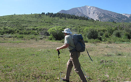
If this land exchange happens, here is the treasure we'd be giving up, middle elevation lands already owned by the public, excellent hiking, hunting, and more. In this photo, we're near the boundary between USFS lands and the BLM lands proposed for exchange, our local signature peak, Mount Sopris, rises above in unique view angle that's delightfully different from that seen elsewhere.
In feudal society, a lord owns your land. You farm it (if he lets you), hunt (if he lets you), hike (if he lets you) or just look at the land by his whim. A man who appears to be in the running for our regional lord, Leslie Wexner (owner of Victoria’s Secret and more), appears to be using money to create a fiefdom. A far as I can research it, Wexner and his smart legal staff are essentially using vast wealth to sway public opinion in various ways, to gain favor for privatizing public land adjacent to their ranch, as an “exchange” for private land they own elsewhere.
A few examples of how the Wexner group is manipulating this process to their favored outcome:
One, Wexner outright bought several properties adjoining the BLM lands in question, with what I feel (and sources say) is the obvious purpose of blocking proposed access easements so they can claim the proposed exchange land has poor access. On the surface you might say, “so what, they bought some land.” But know that some of the acquired parcels were being considered by land managers to be used for easements or outright purchase to provide public access. The story is Wexner’s minions got wind of that, and quickly snapped some of these properties up at over market value — obvious purpose being to shut down any hint of public access to the public land. Building the fiefdom, as it were.
Two, according to my sources Wexner has promised an adjoining subdivision a donation to their “water fund” and also promised such adjoining private land owners they’ll been given foot travel access to a portion of the now public land even if it becomes private. The latter is huge, as at least some of those land owners might have perhaps protested the exchange deal due to their access to adjacent public land disappearing in a puff of well financed smoke. Instead, they still get access — we don’t. Sickening. And to think these property owners will receive cash money if the deal happens? That totally invalidates any opinion they have about the matter. Essentially, they’ve been paid off or at least appear to have been. Really, kind of dumb for them to have taken any of those concessions and then expect anyone to listen to them speaking in favor of the exchange. Sadly, BLM and local officials appear to be listening to this tainted support for the exchange.
Three, the main piece of land Wexner proposes to trade for the exchange was, in my view, obviously purchased specifically for that purpose — a 557 acre property known as Sutey Ranch that’s seductive to mountain bikers as it could possibly add trails to an existing cycling area. On the surface, that sounds ok. But the Sutey is significantly smaller in acreage than the BLM lands to be exchanged (1,470 acres!), is not the wonderful backcountry land that’ll be ‘disposed’ of if this process is completed — and most importantly, our Department of Wildlife states that if the Sutey Ranch becomes public land under their jurisdiction, they’ll require it to be managed for wildlife conservation — not recreation. What that means is is may not have _any_ mountain bike trails, and will be closed entirely to human use for many months of the year. (Note, the main BLM parcel of exchange lands is 1,269 acres, with two smaller parcels making the total 1,470.)
Four, BLM would also receive a $1.1 million donation from the Wexners – said to somehow be earmarked for developments of a site-specific management plan for the newly acquired parcels, and for their long-term management. Legal bribe or what? Cash is cash and has an influence. Again, the whole thing would smell much better if the cash part had been left out of the deal. Considering their land purchases to block off access, money for Prince Creek Homeowners, an army of lawyers and consultants from Western Land Group, and this BLM ‘donation,’ the amount of coin the Wexners are laying out must be phenomenal. Amazing what selling lingerie can do.
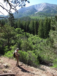
On the access trail a short distance before hitting land slated for privatization. Click to enlarge.
Indeed, reality is that the public land Wexner wants to take is astonishing in its value as a public amenity — “disposing” this to private ownership would be tragic. The land in question does not compare to the Sutey Ranch; it is vastly superior in numerous ways such as it being mid-elevation backcountry where hiking, equestrian and bicycle trails could be built that had a much more “backcountry” spirit than those of the Sutey area; wildlife is much more abundant and varied and could easily be accommodated by careful trail design and recreation management (the area is already ranched, which doesn’t seem to be bothering the animals a whole lot); it is already public land — we should proceed with fanatical care on ANY deal that privatizes public land (and view most such deals with extreme skepticism if not outright hostility.)
One of the worst parts of the Wexner effort to sway public opinion is it appears his men-at-arms have somehow spread disinformation to us serfs, to the effect that the public land in question is virtually blocked from public access. Indeed, one of the strongest cases for Wexner acquiring ownership of the public land through land exchange is that it’s “inaccessible to the public.” That would actually be a good reason (provided the exchange involved creating public land that _was_ to be totally accessible for public recreation, which it does not as the Sutey ranch in exchange will have a large human restricted area for wildlife). But, this accessibility issue appears to be a lie or at least ambiguation (and more, a situation that appears Wexner and his staff attempted to create through various manipulations such as buying up surrounding property and blocking informal access, which is nauseating). Below are more facts (and yes, some blog style opinion as well):
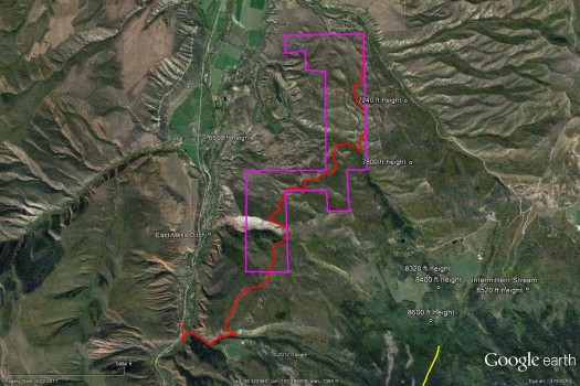
Proposed land exchange as viewed in Google Earth: purple encloses public land slated to become private, red shows hiking route that sticks almost totally to well used trails and two-track dirt roads. See links below to download this Google Earth file for viewing on your local computer. If you choose to hike this, most of the route shown is proven to be the best line, but know that the section from Lions Mane north to might be better walked along the fence lines, download the Google Earth file and the GPS files to make this clear by viewing on your computer.
If you’re not from our WildSnow HQ area here in west central Colorado, you might yawn at this post. Please do not. This sort of legal theft is going on everywhere. It’s disgusting and the system that allows it needs to be changed. Links below cover all this. For now, how about some maps and GPS data? Locals can use this info to go hike the beautiful, downright spectacular land that is slated to be stolen from the public commons. Non locals can see what throwing money around can do to steal our heritage. Check it out. Be aware. Very aware.
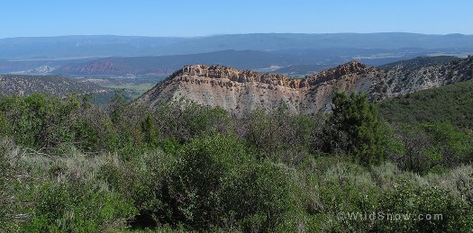
Unique view from BLM property slated for 'disposal" to private ownership. In this shot, we're looking northerly at a formation called the Lions Mane, which would end up mostly in private ownership if this deal goes through -- and of course the view in this photo would be eliminated from enjoyment by the public. Town of Carbondale is visible in distance to left of Lions Mane, and interestingly the ranch that Wexner bought to try and exchange for this is on the reddish hill in the distance just above Carbondale.
You’re probably thinking, what exactly is being offered in exchange? Yep, the Wexner legal trust went out and purchased a very nice little ranch near here, one that appears to offer a few recreational amenities mainly for mountain bikers (but actually may not, due to priority of wildlife conservation). To nearsighted politicians and citizens this appears to make this thing a good deal (even though the public land is 1,470 acres, compared to the tiny ranch at 669 acres!), and that along with Wexner promising to spread ever more money around to various non-profits. A modern day feudal lord: instead of war horses, Wexner uses war dollars. Mainly we need letter writers to oppose this potential tragedy. Is the pen mightier than the sword of the lord? Let’s find out. Click links below for details on everything. Meanwhile, a few more maps for locals wondering about the lies pertaining to public access for this amazing chunk of land.
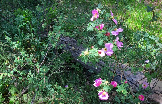
Wild roses on land slated to be taken from public ownership.
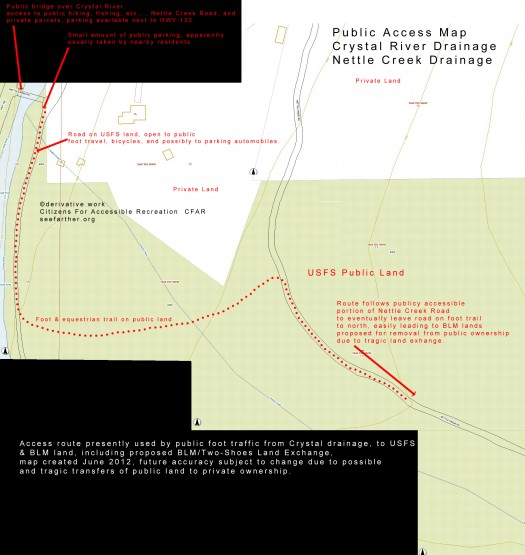
Main access, from the west, Crystal River drainage. Marked trail is approximate, see Google Earth and other items here for data you can use for hiking. Click image to enlarge, or download via links below so you can read everything.
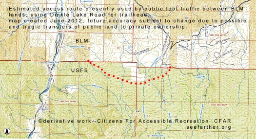
Approximate route to access BLM lands from Prince Creek Road using overland off-trail hiking. Considering the Crystal access shown above, this makes two totally legal access routes for this public land. We've researched this route on the ground, and it appears a better route might follow the fence lines more closely, or else use game trails at higher elevation. Click image to enlarge.
Download GPS track and data for hiking the proposed Mount Sopris Land Exchange, (AKA: Wexner, Two Shoes, Sutey, etc.). This is in GPX format that works in many GPS units. Note that section of trail marked from Lions Mane north to BLM corner 015 might be better hiked along fence to east of marked route (most of route is verified.) The GPS data uses GPS datum WGS84; be sure your unit is set to that (most are).
Download Google Earth File (install Google Earth software first. Please note that property boundaries on this map are approximate, while the marked trail is guaranteed not to use private land even though it appears to do so in a few places where it’s close to fences.)
Download Garmin GPS file to install on your GPS or use in Garmin Mapsource software.
Crystal drainage access map, same as displayed in post above, showing exact private land and general hiking route, download-display, exact locations of legal hiking subject to verification.
Recent article in Aspen Times, written by person who’s actually been on the land in question rather than hearsay.
BLM offical information about the land exchange.
Route Description from Crystal River Valley (taken from several sources, best used with GPS unit, route description subject to verification, use at own risk).
This description describes a lengthy hike that takes a rough diagonal across the totality of BLM land proposed for privatization. Most parties will want to take a shorter but still satisfying hike into the beautiful Lions Mane area, perhaps a mile or so beyond, then return.
As of this writing, there is easy and legal access to this area from the south, but no formal public access or egress on the northern end of the public lands. That said, the northeast corner of the public land is several hundred feet from a public road right-of-way and what many people view as historical easements do exist. Use your own judgment here; we make no recommendations in terms of northerly access/egress, though we’re comfortable saying that prosecution for trespassing here would be unlikely.
The trail described below is occasionally marked with temporary social markers such as rock cairns or flagging, locals attempting to control use of public lands adjacent to their private holdings have been removing all markers soon after they appear. Doing so is juvenile and only has the effect of causing the public to wander and create threaded trails. We’d request to the locals that they stop removing markers and let one main trail remain marked. When you go up there and scour the trail markers, you’re acting like you’re in kindergarten.
To begin the hike, Drive HWY 133 (about 7 miles north from Carbondale, or drive south from McClure Pass) and park near the Nettle Creek Road Bridge crossing the Crystal River. Reliable parking is available about 300 feet north from bridge on side of HWY 133 — one or two spots may be available on east side of bridge, but these spots are being manipulated and possibly illegally signed and blocked by by what appears to be people living nearby. It’s better to park on the roadside just as people fishing do, though be sure you’re in a wider shoulder spot, well away from the pavement. We wouldn’t be surprised if the childish locals called in complaints about parking near the highway and attempted to thus harass trail users.
From the east side of the bridge, head south across a small creek on an obvious dirt road road along an irrigation ditch to a rusty and somewhat hidden gauging station on the ditch (to your right as you walk south). Look left for a road cut up and to the north with 3 steel stakes at the start (these appear to be planted to block ATV traffic, by whom we do not know and they may be illegal and subject to removal.) Walk up the road cut.
After a few hundred feet up the road cut, follow an obvious powerline for about 200 yards then head right to the creek. Cross the creek on a well used trail to a small irrigation ditch, cross a 2×12 plank bridge over the ditch (again, we wouldn’t be surprised if this plank was removed by locals) and climb to the improved dirt Nettle Creek Road. Walk up the road to the Carbondale water treatment plant and look left for a road cut just a few feet before the treatment plant. Follow this up the a short distance, then head left on an obvious foot trail that generally follows the left side of the creek.
(Regarding Nettle Creek Road, you may observe that this road is gated just north of the bridge. This is why you walk south and take the variation described above. There is some question as to if it’s legal to gate the Nettle Creek Road. We’re of the opinion that it’s legal to climb over the gate and walk the road. If you do so, be ready to be harassed by the childish locals. Better to take the hike as described above.)
At any rate, you’ve reached the water treatment plant on Nettle Creek Road, and you have left the road and are hiking southerly up a drainage with a small creek. After a steep climb on obvious trail, stay on the easily followed trail and head northeast and gently down in to a drainage; look for cairns (though all cairns and markings tend to be removed by NIMBY locals attempting to discourage public use of these lands). Cross a boggy patch of wild iris, and when you reach a drift fence, go through the gate (grazing drift fence on public land) Eventually you pass through another gate, this time at the BLM boundary to the proposed land exchange acreage.
Continue northerly and gently descend into the Potato Bill drainage. It is critical to follow our mapped and GPS documented route in this area, otherwise you’ll encounter difficult oak brush. Pass through a grove of fir and enter a meadow bisected by the fence running north/south which divides BLM lands from Wexner private property. Continue north and cross Potato Bill Creek into a grove of very large oak trees at the southern base of the Lions Mane scarp formation. Head up the hill (dirt and scree, sparse timber) somewhat parallel to the fenceline on a well used trail (again, this is the public/private boundary). When you reach the east/west fence at the top of the Lions Mane, head west to enjoy a fantastic view of the Lions Mane, across the Crystal River valley over to Thompson Divide and up the flanks of Mount Sopris. A good name for this high-point is “Lions Mane Overlook.”
From Lions Mane Overlook you have two choices.
1. Simplest is to continue along the fenceline north, then go north a bit more till you hit dirt roads and heavily used trails leading to Thompson Creek and so forth as described below.
2. For less fence walking and more backcountry hiking, from Lions Mane Overlook head westerly on the Lions Mane ridge for a short distance, then follow less distinct trails north and northeast about 1/2 mile to pass just feet north of an important private/public property fence corner (see map).
With either choice 1 or 2 above, from the property corner follow a short section of trail north and east which leads to two-track which you then follow easterly for about 1/2 mile where you swing north and stay on two-track to eventually reach Thomas Creek. To stay on public land here, your best choice for hiking (or bicycle riding if you hauled one up here) is to swing east on an obvious two-track (well used by the adjoining ranch as their own virtually private road) which follows Thomas Creek upstream for about 1/4 mile where you’ll see a very obvious two-track road cut heading steeply north off the main two-track road. Stay on this road as it leads to obvious private/public property line fence, which you pretty much follow all the way north to the far northeast corner of the public lands. This last part of the hike is actually quite nice, taking high somewhat dry sage flats that are scenic and easily walked. Reverse the route to return to the Crystal River drainage. Full hike is 7 miles one way to far northeast corner. Parties of average fitness will need a full day to do the 14 mile out-and-back trip from the Crystal River drainage.
Overall, the trails described above should be considered unmarked, some smaller sections are intermittent due to livestock and wildlife wandering not establishing one main route. For success, travel with a person who’s done the route, or use a GPS loaded with the data you can download in the links above and below. Also note that the first section of trails described above is excellent hiking on USFS land that will (hopefully) remain public even if the BLM land exchange goes through. But the prize is the BLM land up on broad shelves, shoulders and ridges. Magnificent terrain with Lions Mane Overlook being the crown jewl.
Unfortunately, we as public owners and users of the commons have a nearly empty arsenal when it comes to opposing these heinous land exchanges. Public opinion is our only weapon, and in this case a man with huge monetary resources has managed to sway public opinion by spreading wealth around (or promising to do so), as well as appealing to some local residents’ nimby tendencies. Thus, we can do two things: 1.) Use media to get the facts out, as I’m doing here. 2.) Write a letter to BLM. Until the final decision on the Wexner exchange, it’s critical to send written comments to the following addresses. Email is just as effective as written.
Steve Bennett – BLM
Field Manager
2300 River Frontage Road
Silt, CO 81652
emails
sbennett@blm.gov
kmendonc@blm.gov
The best opposition letters cover specific points (see end of this blog post for suggestions) but writing a simple letter or email saying you oppose the land exchange is useful as well. How much influence these sorts of letters have is an open question, as this is not a voting process, but at least let yourself be heard. If this land is stolen from us and you did not speak up, you’ll regret it the rest of your life.
(Please note: I, Lou, the author of this post, am not against the land exchange process when it is obvious public good and equal exchange of value comes out of it. Indeed, the Federal exchange process was near as I can tell indeed designed to accomplish just that (though it turned out to be based on poorly written laws and rules that need revising). More, I’m a private property advocate who is not against land owners doing the best they can with what they have — rich or poor, thousands of acres or a half acre. What I’m against here is a clearly unequal exchange in value, including a net loss of public commons acreage that happens to be an incredibly wonderful amenity for a variety of healthy and essential recreation.)
WildSnow.com publisher emeritus and founder Lou (Louis Dawson) has a 50+ years career in climbing, backcountry skiing and ski mountaineering. He was the first person in history to ski down all 54 Colorado 14,000-foot peaks, has authored numerous books about about backcountry skiing, and has skied from the summit of Denali in Alaska, North America’s highest mountain.
