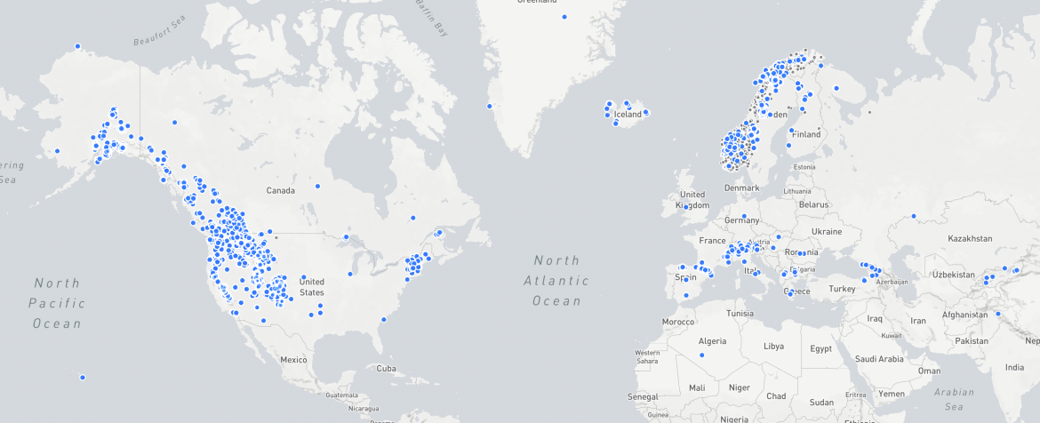
Snow observations submitted by the community. These data can help fill in the gap of snow data voids across wide swaths of the landscape. Screenshot: app.communitysnowobs.org
As backcountry skiers and riders, we can access deep parts of the mountainscape. These regions are often unmonitored by SNOTEL sites. In a few easy steps, we can help fill in these data gaps by collecting snow depth information while touring.
Last Sunday was the annual (and in-person) 2022 Northwest Snow and Avalanche Workshop (NSAW). And as much as events like this prime the system for backcountry travel. Nothing gets the brain triggered like listening to snow scientists and avalanche pros discuss their craft.
One key takeaway was a reminder that we can participate in community driven data collection. This was most evident when Nina Aragon, a graduate student at Oregon State University, spoke about the Community Snow Observations project (CSO). Here’s the gist: scientists still rely on remote sensing stations to collect reliable snowpack data. These data are also confirmed and enhanced with satellite imagery. Still, large data gaps exist. Remote sensing stations are often located in easy-to-access places. (This makes sense in terms of construction and maintenance.) What scientists really want are data from even more remote locations.
Aragon noted in her talk that winter snow is an ecological bridge. “One of the biggest services that snowpack provides is that it serves as a natural reservoir that bridges winter water storage to summer water availability when both human and ecological demand are at their highest,” she said.

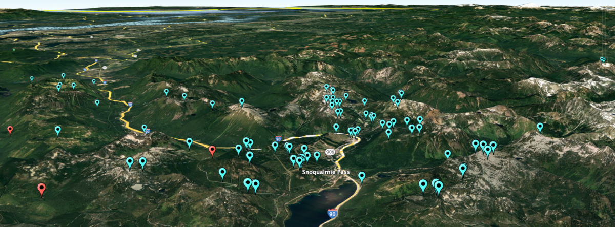
Snoqualmie Pass. Pink markers indicate automated SNOTEL stations and blue markers indicate CSO observations. Note how CSO observations fill-in observational gaps across the landscape. CSO observations in blue, SNOTEL sites in red.
Aragon went on to explain that the distribution of the snowpack is still relatively unexplored in many parts of the U.S. Enter, backcountry skiers and splitboarders.
At one point, an interesting and revealing slide was displayed; it highlighted Snoqualmie Pass and the lack of monitoring stations in some high-value areas. As Aragon and Dr. David Hill, also from OSU, wrote for NWAC, “backcountry users are often in remote parts of the landscape where we typically do not have monitoring stations, the snow observations they submit help to fill-in gaps in our observational network.”
Only a few SNOTEL sites are within the scope of the Snoqualmie zone, whereas we can see that most observations are submitted from the backcountry community. These data inform researchers about the state of the annual snowpack across wide swaths of the landscape and both short and long-term hydrological trends. Further, with more reliable data inputs, scientists get a better handle on how the winter’s snowpack may or may not meet human and/or ecological demands.
The video outlines the basic steps for snow depth data collection.
CSO was launched in 2017 and asks citizens to collect basic data; snow depth. You can use a probe to collect data and a simple app, Snow Scope, to enter that data in the field. The app can get complicated as it was developed for and by Propagation Labs and their Snow Scope Digital Snow Penetrometer.
For basic snow depth collection, simply tap the “+” sign in the lower right corner of the screen, tap the “Snowpack Height” icon, enter the height (in cm.) and save. The app will also save geolocation. These data will be publicly available if the app is set to public.
You can also view community submitted data here. For deep dives into snow data and observations (we’ll have more on this in the future), check out mountainsnow.org. The site provides a handy tutorial to access the layers of data available.
Let us know in the comments of any community-driven data collection projects folks should know about.
Jason Albert comes to WildSnow from Bend, Oregon. After growing up on the East Coast, he migrated from Montana to Colorado and settled in Oregon. Simple pleasures are quiet and long days touring. His gray hair might stem from his first Grand Traverse in 2000 when rented leather boots and 210cm skis were not the speed weapons he had hoped for. Jason survived the transition from free-heel kool-aid drinker to faster and lighter (think AT), and safer, are better.
