Jarrett Luttrell
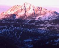
South Maroon Peak with first autumn snow, the Southwest Couloir splits the middle from the summit. (©Luttrell)
Matt Halbakken kills the engine of the snowmobile and turns around to see if I’m still on the tow rope. “Man, I just don’t get it!,” he says in a concerned tone, “Did you make a bet with someone back along the way or something — are you really going to do this?”
I get that a lot. Sometimes I try to explain, but doing so is usually a lost cause to anyone who has not endured the sadistic pleasures of the solo mountain mission.
We all go a little stir crazy by the end of a long winter in the mountains. Some pack up and head for the desert. Some go for the ocean. They go looking for summer wherever they can get it. But for me, the end of the semester means finally having the time to get out on an epic splitboard mountaineering trip.
South Maroon Peak, 14,156 ft., is one of the most elusive summits from the Gunnison side. It is only visible from a handful of places, and even then it is often represented by a dark veil of bad weather under otherwise clear skies. Not only does South Maroon hold several of the Elk Mountain’s best lines, but it’s also the true “Maroon Peak,” as it’s the highest summit in its group: the two distinctly shaped peaks known as the Maroon Bells, (the classic reddish striated summits shown in countless Aspen promotional photos). In fact, because of the lack of drop and distance between South and North Maroon Bells, you could argue that North Maroon is merely a sub-peak. Whatever the case, when you focus on South Maroon as a goal, you feel its power.
The first time I came close to the Maroon Peaks, I’d come over West Maroon Pass in the rain to get to Crater Lake. I thought it might clear, but the the rain turned to sleet and hail. It was a cold night in a wet sleeping bag. I headed back over the pass the next day — a bit glum that I had not even had the chance to see the mountain, much less climb it. A month later I drove over Kebler and McClure passes to get to the Aspen side. This is when I saw The Maroon Bells for the first time. I was awestruck, to see them already covered with snow beyond golden turning aspens, but shot down for the climb. That was the case a second and third time as well.
By early May of ’00, my taste for mountaineering had evolved from simple hikes to also include snow climbs and snowboarding. Matt Halbakken and I, had tried for a Maroon snowboard descent using the Bell Cord Couloir, but with limited success. So this trip was a rematch, a chance for redemption. Also, I felt that the solo mission was the only way to approach this mountain with the reverence that it deserves.
So much for noble ideas. As I stand alone, watching Matt’s snowmobile headlight disappear into the dark woods, one thought dominates: will this be another wild goose chase?
– Sunday, May 8th –
10:oo p.m. Emerald Lake is shadowed from the moon by Mount Baldy. The lake has been rendered shoreless with the wreckage of a major avalanche. Traversing above the lake is difficult, but necessary due to thin ice. Also, the debris may have created an unstable, floating shelf beyond the actual shoreline.
11:oo p.m. 10,710 ft. Schofield Pass signifies the point of no return; the entrance to the dark timber of the White River National Forest. There are some confusing places at the switchbacks. The snow is deep and soft, leaving very few clues of the road beneath.
Midnight: 10,360 ft. Schofield Park opens the view of surrounding peaks. There is a small opening in the creek. I refill with water, as it may be awhile until the next opportunity to purify water without the use of fuel. There are huge accumulations of snow here. The trailhead for West Maroon Pass is just on the other side of the creek, and contours of an old road flow through open timber into the Maroon Bells-Snowmass Wilderness. This is the East Fork of the South Fork of the Crystal River. During the first mile of this section the road-cut turns to trail, and requires climbing out of the bottoms to avoid a bad sidehill through willow patches and over an open creek.
1:oo a.m. The valley opens. The snow route is about the same as the summer trail. It just stays on the valley floor, sometimes crossing snow bridges to avoid side hills and obvious avalanche slopes. I find several enormous moths frozen in suspended animation. I can pick them up with my hands.
2:oo a.m. The head of the valley has some ridges rolling out and to the north, towards Frigid Air Pass. The last one before a deep gully seems to be the best. It is mellow and easy to avoid avalanche terrain to gain the huge and barren basin running almost parallel to the valley below. At the head of this upper basin is Point 12,648. Frigid Air Pass is on the next convex hump to the southeast, to the right. There is also a short gully in the corner that is not as steep. The summer route would be better with less snow. A quick dig reveals better snow than I’d seen elsewhere during the season. The hard top layers of winter avalanche debris are comforting, but almost destroy my shovel. There is still some depth hoar on the ground, but fairly consistent, and more importantly, frozen layers above. This is encouraging, as it’s the same aspect as Maroon’s southwest face.
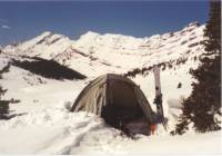
3:oo a.m.: 12,400 ft. This is a very intimidating and mentally confrontational moment. I’m at Fridgid Air Pass, and get my first view of South Maroon Peak.The southwest face, while smaller than the grand east face, is no less fearsome. The improbable couloir cuts through the sweeping moonlit anvil, all the way from the summit. It is difficult to gage how steep it is. It looks just awful from here though; it makes me a little sick to my stomach. I don’t have to climb it, I could just camp down there and take pictures. With that, I assemble the snowboard, shoulder my pack, and follow the tiny spot of my headlamp over to the dark side of the ridge for a banner night run down to my basecamp location.
4:oo a.m.: 11,360 ft. Fravert Basin basecamp is set up. I crawl deep into my sleeping bag, listening to the eerie, but beautiful sound of howling coyotes down in the timber.
– Tuesday, May 10, 2001 –
1:oo a.m. Awake, I realize my solitude once again. The heavy silence in this place that can be unbearable at times. I feel a strong sense of anticipation, but occupy my mind with preparations.
2:oo a.m. Skinning up to the base of Maroon is like climbing a huge staircase of frozen waves. I wish I’d brought my homemade splitboard crampons for the steeper sections.
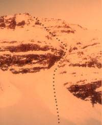
3:oo a.m. I’m in the hanging basin, getting a fully foreshortened view of the face. The route’s deviations can be spotted from here. Initially, the only break in the lower cliffs of the face is an icy, steep, and generally dirty looking slot. That must be where some mountaineers have mesured the slope at 70 degrees. While more aesthetic in its continuation of the line implied by the upper couloir, it is not, in my opinion, actually part of the main couloir. It is a spur, used by ice climbers. While I would not rule out a ski or snowboard decent by belay, I am sure it would be time consuming, and disrupt the flow of the upper couloir descent. Anyway, aesthetics aren’t everything. Thankfully, the main couloir becomes visible while working to the left of the base. It intercepts the upper section from the left about a third of the way up, and continues on its own less prominent track, out onto the upper flanks of the southwest ridge. Other than the upper couloir itself, it has no options to the left. I note: stick to the cliffs on the left when in doubt at the junction a third of the way up.
4:oo a.m. The apron on the left ascends to a cradle under the cliffs, and the main couloir entrance opens to the right. A snow pit reveals similar layers as Frigid Air Pass: thick frozen concrete under the soft new stuff, with two differences: one good and one bad. The first thing, more consolidated ground hoar, makes for better stability. The second thing, an inch of sun crust on the surface, makes climbing very difficult. Another thing, contributing to stability and to the climb, is that the whole right side of the lower couloir has avalanched. I lash my crampons, shoulder my board on my pack, and draw my axe to posthole towards the debris. It is more firm, and safe.
5:oo a.m. The lower couloir quickly becomes a constant pitch of about 50 degrees, and probably exceeding it just before the junction a third of the way up. I stay right for another hundred feet to favor the frozen avalanche debris, then traverse back left, to meet the upper couloir.
6:oo a.m. I’m in the upper upper couloir. I work solid snow and rocks on the right side, then cross the middle to work up along the cliff wall. At this pitch, it seems there are two vertical feet for every foot of snow perpendicular to the slope. Postholing here is laborious.
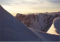
7:oo a.m. The flanks offer some relief to the confines of the couloir. It is wind stripped and rocky terra at a less severe angle. Rock ledges offer protected rest spots and better views. Maroon casts a shadow into the western sky between predawn tints of red and violet. Sundogs glimmer above a cairn marking the southwest ridge route. I begin to slow down, realizing the eminent summit. This is a walk in the sky to be savored. The gaps in the ridge’s cornice offer the first views of Pyramid.
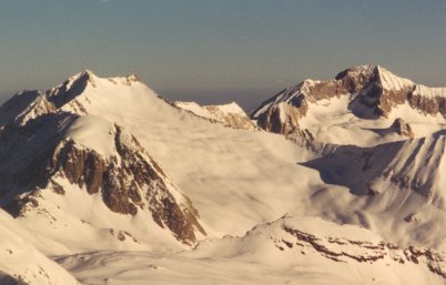
Views from the summit of South Maroon show incredible terrain. Capitol Peak on the right, Snowmass to left. (©Luttrell)
7:3o a.m. 14,156 ft. At the summit, the panorama opens to Snowmass, Capitol, and North Maroon. The sky is clear, the sun is warm, and there is not a breath of wind. The silence is very strange. I spend a little time walking the north ridge to the Bell Cord. It only takes about fifteen or twenty minutes to return. That is where Matt and I had turned around about one year ago. I feel as though I actually belong here this time. I feel at peace. Lounging on the summit, taking pictures, adjusting things, and watching the sunrise, I begin to get chilled.
8:oo a.m. The descent off the exact summit of this peak is very nice. Soft powder on a mellow slope allows about a dozen casual warm up turns before the couloir entrance. At the entrance the snow and the slope stiffen to a frosty 60 degrees. Another hour or so would soften the snow, but my concern is more with safe snow. I drop in with a very slow turn to the toe edge (for a better self arrest stance), and carve up to the transition to initiate the heel edge. Endo-lip-skid not an option. Carving is important. Snowboards have less edge to work with. Steep is the word here, but it relents to 50 degrees after the first couple turns. The difficulty here is the frozen avalanche debris. It is rough and noisy. My board takes a real beating as I exit the couloir. I take a moment to loosen up, and let the blood back into my feet again, then ride smooth open slopes from the apron, into meandering ravines and many terraces to the valley floor.
9:oo a.m.: 11,200 ft. I split my board and head back to camp with a sweaty grin on my face.
– Escape, Wednesday, May 11th, 2001 –
4:oo a.m. Shouldering my pack, I head towards Bellview Mountain at the head of the basin.
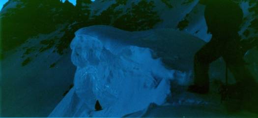
Getting over this cornice was the hardest move of the trip, and it wasn’t even on the mountain! (©Luttrell)
5:oo a.m. A dark wall stands in place of the mellow little slope I had seen from camp. I thought this slope would be a shorter and less threatening option to the way I entered Fravert Basin. I have second thoughts as I begin to cut a traverse up and across a powdery leeward slope. It is shorter, but too steep at the top for skins and backpack. Also, what looked like a break in the cornice guarding the rim is actually only a wind drift at the lip. The drift is too steep to skin and too soft to side step. I can almost reach a pole over the top from here, probably ten feet. I’m not sure I can pull my ass over the lip, let alone with all my gear. I’m tempted to break out the rope for the first time. I could tie it to the pack and hoist it up from the top, making the climbing easier. Sitting on a shelf beneath the cornice for awhile, I wrap crampons, draw an axe and pull out a 36″ snow picket. At the last minute I decide to just shoulder the pack and snowboard and go for broke. I attack the cornice for about thirty heart-pounding seconds, finally mantling over the top.
6:oo a.m. — 12,400 ft. Descending from the pass is a great run. It is more than a thousand feet to the East Fork of Crystal Creek, and it doesn’t stop there. With a little help from my poles I was able to cruise down valley for another mile or so. I put the skins on one more time in the timber to gain a little more vertical on the last section into Schofield Park. This makes for a better run than the side hills and willows over the open creek.
7:oo a.m. — 10,360 ft. Schofield Park The sun is up. I purify water again.
8:oo a.m. — 10, 710 ft. Schofield Pass is a huge welcome. I assemble the snowboard and head for Emerald Lake. There are more great turns to be had from the lake down a narrow gully to my starting point (see intro). From here it is a full day’s travel back down to Gothic. I reluctantly use the klister that Halby gave me, but it does the trick where my skins would have surely become soaked and dirty.
11:oo a.m. I arrive in Gothic, nap on a picnic table, eat a lunch, dress down, and bandage my pinky toe.
1:oo p.m. To my dismay, the road from Gothic to the Snodgrass trailhead is almost completely melted out. I strap everything to my pack, and toil my way up the last three miles in my soggy snowboard boots.
4:oo p.m. Back at the trailhead! Bone tired and dirty, I have an easy time time believing where I’ve been. I let out an obnoxious groan with the removal of my pack. The suspension in my car sags with the weight, and I grin at the strange looks from the trailhead toddlers.
(Editor’s note: Jarrett Luttrell seeks to experience the Fourteeners as the rides they are meant to be. Perhaps in his next story he’ll share about his moonlight descent of Mount Democrat via the North Face Direct.)
Beyond our regular guest bloggers who have their own profiles, some of our one-timers end up being categorized under this generic profile. Once they do a few posts, we build a category. In any case, we sure appreciate ALL the WildSnow guest bloggers!

